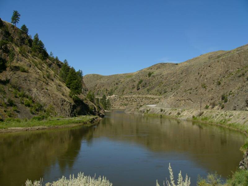
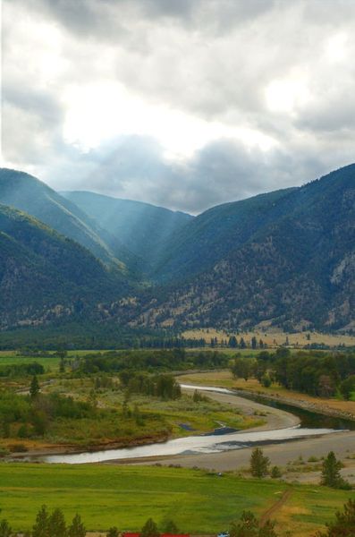
To the south, is the “Okanogan” and to the north, is the “Okanagan”, and connecting the two is the gentle and meandering Similkameen River with a place called Shankers Bend which is now poised to challenge two nations as they both react to issues of climate change and energy.
This story began with a request from the State of Washington to Public Utility District No. 1 of Okanogan
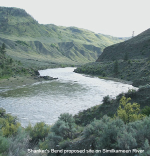
County (PUD) to identify potential water storage areas and power generation sites that could feed into the state power grid. For the small publicly owned utility there was one on the books from many years ago called Shankers Bend Dam.
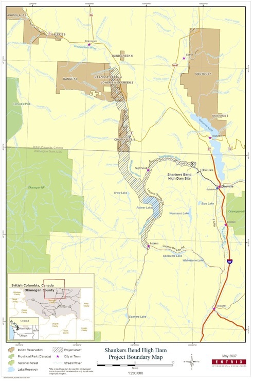
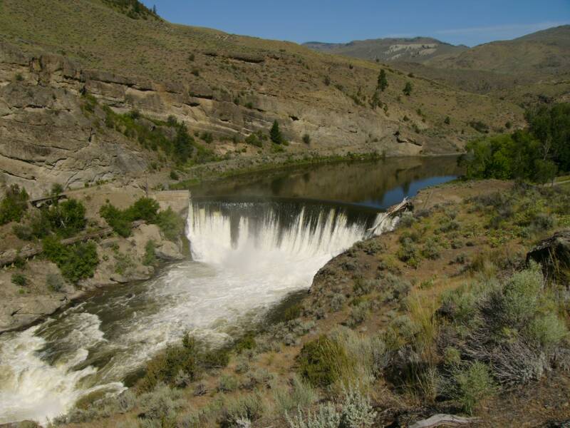
As it stands today, the proposed $260-million dam would be located eight kilometres northwest of the Washington town of Oroville and above the Enloe Dam on the Similkameen River, which was built in 1920, but ceased to produce electricity in 1959. The county is also seeking permission to reactivate power production from the Enloe dam.
Half of the flood zone behind Shankers Bend would be in British Columbia encroaching on close to 25 kilometres of the Similkameen Valley and flooding 9000 acres south of Keremeos and west of Osoyoos. It would cover riverine habitat including existing lakes, private farmland and abandoned mine sites.
The dam would produce an annual average of 280,000 megawatt hours, but for PUD, generating electricity isn’t as important as water storage. The project would create a “regionally important water storage" to satisfy municipal and agricultural needs. A submission by the Washington State Department of Ecology states the reservoir could also represent an important source of cool water for the benefit of fish downstream during the heat of summer.
Okanogan County and northeastern Washington are drying out, and while local officials are nervous about using the “climate change” term, body language displays a certain discomfort when explaining just how the region will plan for future drought conditions.
The Shankers Bend Project is being proposed for study in coordination with the State of Washington, Columbia River Water Management Program. The 2006 Washington State Legislature overwhelmingly supported legislation to develop new water supplies and improve water management, which included a commitment of $216 million to nurture new water catchment solutions.
Water has become front and centre politically on the eastern side of the Cascade Curtain. Reelected Washington State Governor Chris Gregoire when referring to new dam projects, responds to critics by saying, “If not there, where? We need to store more water in Eastern Washington.”
While the Canadian Okanagan experiences the role of this country’s sunny California and is one of the fastest growing areas in the country, this same valley to the south is considered the remote and barren northern part of America with a sparse population that gains little attention, even from the state of Washington itself.
In fact, when Washingtonians in Seattle and Spokane traveled paved streets in motor cars and trolleys, the remote Okanogan still relied on stagecoaches and stern-wheeled riverboats coming up the Columbia River for supplies and contact with the outside world. In the 1920’s, historian Alvin M. Josephy, Jr., described the area as the "last outpost of frontier life" in the American West.
In recent years, the forgotten aura that surrounds Okanogan County has been habitats gain in the Similkameen watershed. Ecosystems on the US side have been largely undisturbed and as the climate turns warmer, the valley corridor has become a north south travel route for species to inch northward in an effort to escape the creeping desert.
But this natural safety valve may soon be turned off, as a body of water fills the valley.
On August 22, 2008, Public Utility District No. 1 of Okanogan County filed for a new license for the 9 megawatt, 54 foot high Enloe Dam and by December 16th, the Federal Energy Regulatory Commission (FERC) issued its Notice of Scoping Meetings, a Site Visit, and solicitation for Scoping Comments.
On December 18, 2008, FERC issued a preliminary permit to PUD for a second proposed project on the same river. The Shankers Bend Project is proposed to be located just one mile upstream of the Enloe Project. In the permit, Shankers Bend is described as a 42 megawatt project with a 260 foot high dam 1,200 feet long. The project will impound an 18,000 acre reservoir with an average depth of 1,289 feet and would impound lands located in both Washington State and British Columbia.
The deadline for submitting comments in favour or against the project closed on February 16, 2009. Meetings were held in Oroville, Washington where FERC staffs were in attendance and “intervening comments” were collected for the projects Environmental Assessment.
The US based Hydropower Reform Coalition is a broad consortium of more than 140 national, regional, and local organizations with a combined membership of over one million people and includes everyone from canoeists to conservationists to lake homeowners.
Coalition members have repeatedly requested that FERC review both the Shankers Bend and the Enloe projects together, given their one mile distance and FERC's comprehensive planning requirements. To date, FERC has maintained that both projects are separate. Rumors have existed for over a year that the Shankers Project is no longer feasible given the potential opposition from British Columbia. But nevertheless the preliminary permit has been granted for the full impoundment area that includes river bottom land in BC.
The Washington State Department of Natural Resources states in a separate submission the dam "may adversely affect state trust lands, aquatic lands ... and the state's natural resources."
THREE OPTIONS AND
UNINTENDED CONSEQUENCES
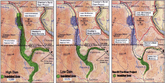
For Okanagan County PUD the Shankers Bend proposal is based on the highest dam level and according to their officials this is because they wanted to maximize the study area in order to understand full impacts of the project. However, there are three different options being considered.
The first option creates the largest reservoir and has a dam that would be 260 feet tall and would generate from 42 to 84 megawatts of power and cost in excess of $260 million. It would create an 18,000-acre reservoir that holds 1.7 million acre feet of water — with half of it in Canada. The reservoir would be larger than Lake Osoyoos which, five miles to the east, crosses the Canadian border north of Oroville.
The second option is a 160-foot high dam that would generate 15 to 38 megawatts of power at a cost of about $115 million. It would create a 168,000-acre-foot reservoir with its northern shoreline ending just south of the Canadian border.
The third option is a large run-of-the-river project that requires a 120-foot high dam that would cost about $50 million and would create 12 to 31 megawatts of power and create a 50,000-acre-foot reservoir which would raise the level of Palmer Lake in Washington.
According to the Department of Ecology in Washington, it is unclear which project proposal will best serve the Columbia River Program objectives. Large storage offers economy of scale in terms of capital construction, operation, and management, but with the potential of greater environmental impact. Small storage has the potential for increased cost, but a lesser ecological “footprint.” Aquifer storage and recovery (ASR) costs are unknown, but has the greatest potential for environmental benefit by returning cooler and cleaner water into the river system.
The department is evaluating several different large and small surface storage options as well as aquifer storage that may include pumped and passive water recovery options to determine which water supply project best meet the goals of the program.
INTERVENER’S HARD TO FIND
While the American critics of the project have emerged through the scoping project, the Canadian ones have been few and far between. PUD insists that they have been active with encouraging Canadian input, and a handful of Canadians agree that contact has been made, but local governments in the Okanagan seem to have been lethargic and have provided little input.
Chloe O'Loughlin, executive director of the BC chapter of the 30,000 member Canadian Parks and Wilderness Society (CPAWS) continues to be perplexed as to why communities and governments in Canada are not actively applying for “intervener status”?
"It's a significant impact," said O'Loughlin who adds that there are only a handful of interveners to date that includes only the CPAWS and Okanagan Alliance of First Nations. She added that her group happened upon the application by accident, but knows that many more groups would have protested if they had known about it earlier.
During the initial process, PUD had formed a committee of five Canadian and five American representatives to keep certain groups informed, and that committee includes representatives from two Indian bands in Canada which are directly impacted, and the Confederated Tribes of the Colville Reservation in the U.S., along with local governments in Canada.
But that input has not translated into over-all awareness of the project and registered interveners. Intervener Status allows entities to register an official protest against a proposal and any impacts that it may have in B.C. Formal intervener status may be obtained by filing a motion for intervention with the FERC. Interveners receive copies of all correspondence filed during the proceedings and are also required to serve all the other intervening parities with any filed motions they make.
Why wouldn’t every environmental organization in BC register as an intervener? And why wouldn’t every community, tourism and agricultural organization in the Okanagan also register? Why wouldn’t the Government of Canada and the provincial government register as interveners?
The answer to these questions remains a mystery and now it may be too late to become a registered intervener.
Critics of the dam are perplexed but they also suggest that the degree of awareness of what’s at risk, as well as the study process might be completely foreign to most local governments, agencies and organizations.
It’s been over thirty years since reservoir waters crossing the border has been an issue in BC.
It took a significant period of time for the local government impacted the most by the project to voice their concern. At a meeting on January 8, 2009, the Board of Directors for the Regional District of Okanagan-Similkameen (RDOS) passed a resolution supporting the notice of intervention submitted by the Okanagan Alliance of First Nations and Canadian Parks and Wilderness BC. RDOS may have recognized they missed the intervener opportunity as they referred to FERC rules and that these are the organizations that will have to present the Canadian argument against the project through the FERC regulatory process.
There could have been endless opportunities for the provincial government to give a heads-up to communities. As early as Fall of 2007, the provincial government was aware of Shankers Bend when Barry Penner, Minister of Environment and Minister Responsible for Water Stewardship and Sustainable Communities sent a letter to Jay Manning, the Director of the Washington State Department of Ecology, questioning the proposed dam.
More recently in February of this year, Alex Atamanenko the Southern Interior MLA (NDP) trying to get an “official” stance on the issue, asked about Shankers Bend during Question Period:
Mr. Speaker, the Americans are spending millions of dollars on a feasibility study to build a hydroelectric dam at Shanker's Bend on the Similkameen River. An 80 metre dam, if built, would flood 7,200 hectares in Canada. The Okanagan Alliance of First Nations and the Regional District of Okanagan Similkameen have stated their opposition as has the Canadian Parks and Wilderness Society.
Will the minister notify the U.S. government that Canada is opposed to this project and will he insist that the government of British Columbia do the same?
The question was fielded by Mr. Mark Warawa (Parliamentary Secretary to the Minister of the Environment, CPC) who answered:
Mr. Speaker, as the member well knows, this government is committed to a cleaner environment. We have invested $1 billion in green infrastructure, $300 million for eco-energy retrofits, and $1 billion for clean energy projects and carbon capture and storage.
Wherever we look this government is taking action on the environment. I encourage the member to support the budget.
Clearly not a real answer to the question.
The provincial government has yet to make an official stand, but Barry Penner himself made a public statement when he informed the Osoyoos Times this past January that he had visited the proposed site during the Fall of 2008.
“I told Jay Manning (Washington Ecology Director) that we would have grave concerns about the so-called high dam proposal that would result in water being impounded on the Canadian side of the border – so he understands that”, Penner told the Times.
But the BC Environment Minister added that he didn’t think the highest dam option was likely, “I get a sense that, while Washington state may want to study the three options, the more likely options are something smaller than the high dam proposal”, he said.
Penner stated that he had met with Federal Environment Minister Jim Prentice on January 15th and raised the issue. Ottawa has been aware of the proposal as the floodwaters encroach on the new proposed site for a national grasslands park. However, both senior levels of government appear to be stealth-like in their communication leading the few interveners nervous that as deadlines pass the only recourse would be through the International Joint Commission and at significant financial costs.
Atamanenko was again on record requesting support for intervener efforts. On February 9th, 2009 he sent a letter to the Federal Minister of Environment Jim Prentice in which he refers to the Minister as already being aware of the project:
“The study has been expanded to involve the US Federal Energy Regulatory Commission (FERC) with a two-year timeline. According to an article in the January 21st edition of the Osoyoos Times, many are concerned that the utility district’s application to FERC is focusing on the high-dam concept.
Feasibility studies are expensive. The fact that millions of dollars are being spent means that the Americans are serious.
At the board meeting on January 8, 2009, the Board of Directors for Regional District of Okanagan-Similkameen passed a resolution supporting the notice of intervention submitted by the Okanagan Alliance of First Nations and the Canadian Parks and Wilderness BC. Under FERC rules, these are the organizations that will have to present the Canadian argument against the project through the FERC regulatory process.
Minister, on behalf of all those who oppose this project, I strongly urge you to:
1) Notify your US Government counterpart and all those concerned that Canada unequivocally opposes this project.
2) Contact the Hon. Barry Penner, BC Environment Minister to urge the Province of BC to take a definite stand against this project.
3) Commit to supporting both the Okanagan Alliance of First Nations and the Canadian Parks and Wilderness Society in their intervention against this project with the FERC.
Just as with your predecessor, the Hon. John Baird, I look forward to working very closely on this file with you.
But just what work is being done? This question remains unanswered as well.
The CPAWS argues that such a reservoir would violate the International Boundary Waters Treaty of 1909, which protects against either country creating a dam that would "raise the natural level of waters on the other side of the boundary" unless agreed upon by the International Joint Commission.
A LESSON IN CHANGE
Dan Boettger is the Director of Regulatory and Environmental Affairs for Okanagan County PUD said he would have rather studied the feasibility of the proposed dam in advance of making an official application, but PUD had to apply officially in order to prevent others from taking on the project. He admitted that they could walk away from the proposed dam if political and capital costs became too great.
But Boettger added, “As a publicly owned utility all of the study and planning information that we gather remains in the public domain, and that information could be gathered by a private sector company or another utility which could then propose the project again”.
Larger utilities might not be so sensitive to community needs and fears. And this is echoed by Ken Farquharson a long time opponent of cross border hydro projects who helped protest against the Ross Dam in Skagit Valley in the 1960’s and 70’s.
“Communities and politicians have to understand how mean spirited the process can become as greedy self-interest can emerge within these proceedings. The process eventually requires legal counsel and expert testimony that can cost hundreds of thousands of dollars – where’s that money going to come from?”
In 1941, under provisions of the 'Boundary Waters Treaty' (1909), the City of Seattle applied to the International Joint Commission to raise the level of the reservoir on the Skagit River which is located south of Hope and Chilliwack. This application was approved in 1942. By 1967 it had become necessary to raise the Ross Dam to increase electricity supplies to the City of Seattle. The proposal would have resulted in the flooding of almost 5,000 acres of the Skagit Valley in B.C. By 1969 outdoor and environmental groups began to lobby against the plan citing the devastating ecological ramifications. The R.O.S.S. (Run Out Skagit Spoilers) Committee was formed in 1969 as a coalition of numerous interest groups which organized protests against raising the dam. After years of protest and a great deal of money, plans to flood the Skagit Valley were delayed in light of the public outcry.
Such events can leave a scenario where the side with the most cash to spend arguing their position, wins the case.
But how much political capital might be spent on creating the high dam option at Shankers Bend?
According to the Seattle Post-Intelligencer, Democrat Gov. Gregoire has been a "green" governor, at least on the wet side of the Cascade Mountains. She champions the Puget Sound Partnership, prods agencies on Hood Canal pollution, and keynotes Washington Conservation Voters and Cascade Land Conservancy breakfasts.
But she’s less popular on the Republican majority located on the dry side of the Cascades. Now she is being accused of trying to attract conservative support by backing and underwriting studies of highly controversial water projects.
The state contributed $300,000 to study the Okanogan County Public Utility District proposed dams. Another dam proposal farther south, near Vantage on the Columbia River, has stirred up greens on the south side of the border.
Years ago, hearing arguments on salmon habitat lost to Grand Coulee Dam, former state Sen. Nat Washington of Ephrata told P-I columnist Joel Connelly, "Go see Crab Creek. It will open your eyes to what the Columbia Basin Project has done FOR wildlife."
Crab Creek drains 5,000 square miles, taking irrigation water to farms and then back into the Columbia River. It is part of the Columbia National Wildlife Refuge, established in 1944 "for use as a refuge and breeding ground for migratory birds."
The creek is renowned as a gathering point for sandhill cranes each spring. It is also home to a spawning population of Chinook salmon in summer and fall, and to summer-run steelhead.
Crab Creek now joins Shankers Bend as another prime location for creating additional water storage in Eastern Washington with a 240-foot-high, 1.5-mile-long dam, costing in the billions that would flood 19,600 acres of refuge and 8,600 acres of farmland.
What does Gregoire say about this? "It's about water…water for irrigation, water for consumption, water to get salmon to the ocean in low runoff years. We've had drought every year since I took office."
In British Columbia, the provincial government has been eager to promote small scale energy but inching towards mega projects like large run-of-the-river projects and even the construction of Site C Dam and there may not be the political will to get tough and defend the Simikameen.
For the Canadian side of the Okanagan, there may be empathy for the valley’s southern neighbours as drying conditions brought on by climate change take a toll, but an alternative plan to come to terms with the problem of global warming for the region has no advocate.
Only time will tell how Shankers Bend unfolds – but the fact remains, there’s not much time left.
(30)
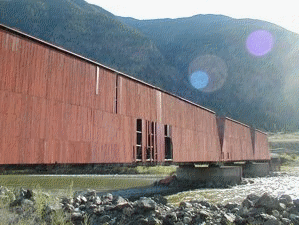
Looming floodwaters and one of the last covered bridges in North America
The old Red Covered Bridge which spans the Similkameen River is a reminder of that bygone time when the V.V.& E. Railway ran up the valley. The line has been abandoned for years now and this bridge is the last of three such structures which could be seen in the lower valley only a decade ago. Today it is used as a highway bridge to the south side of the river and to the Ashnola, but tomorrow it may be underwater.
Chloe O'Loughlin says there is much at stake, and worth fighting for. The reservoir would flood a delicate ecosystem that is home to 16 federally listed species at risk, including the long-billed curlew, Lewis' woodpecker, tiger salamander, Great Basin spadefoot toad, Umatilla dace, Columbia mottled sculpin, and western rattlesnake. The reservoir also has the potential to affect two B.C. protected areas: the 25,889-hectare Snowy Protected Area and the 9,364-hectare South Okanagan Grasslands Protected Area, as well as flooding aboriginal reserve lands.
The CPAWS insists the commission should obtain "clear evidence of consent" from the government of Canada prior to approving a preliminary permit application that proposes to flood part of Canada.
The maps above represent Shankers Bend impact areas. Click on the maps to visit an enlarged view